This morning, I rise, open the windows and feel the sun warm my face. While still early it must be in the 20’s already. Chris, as usual, sleeps in, and I write. When he wakes we pack our bag for our hike to Sant’ Antimo and head to Bar Alle Loge for breakfast. Bummer, the bar’s closed, so it’s across the piazza to Fiaschetteria and to purchase an IHT in the nearby Tabbecheria instead.
After the usual cornetto con crema for me and a bombolini for Chris with two cappucini, we plan our attack for our hike. First question, should we stop and buy some water to take with us? Nah, Chris thinks since Isabella says the hike takes about 2 ½ hours and we’re pretty fit, we shouldn’t need it for that “short walk.” Are you feeling my pain yet?
We use her notes, specifically where she says the trail starts on “a side street uphill and just to the side of Bar Terrrazzo outside the walls on the road to Grosseto. Locate an iron sign with the trail marked.” In specifics, the street lies to the left of Bar Terrazzo, as you’re facing the bar, which is near the small traffic circle above the Fortezza.
We find the paved road, which pretty quickly becomes a white road (i.e., dust and broken gravel). We discover the markers, squares with a horizontal red and white stripe. They can be painted on trees, stonewalls, fence posts, etc. Markers can also be trail signs, which are maps on metal posts. As we examine the first of these maps, we realize the trail from Montalcino is really a subset of a larger trail from Siena to Castel Nuovo Del’Abate, the town above Sant’ Antimo. By the way, Castel Nuovo gets its name from a new castle, well, not so new any more, built in the hamlet for the Abbot of the Monastery. Apparently, the castle still exists within the town but I digress.
 As we meander along, I take a picture of a trail mark (I had intended to take copious notes and pictures in order to update the slowtrav.com website with this information) but realize that I haven’t charged our digital camera’s battery since we arrived in Italy over ten days ago – DOH! Well, I have one good picture of a trail mark and if I’m lucky, maybe later I’ll get one more picture of something else.
This part of the trek is supposed to be mostly downhill, according to Isabella and others but I’m here to tell you that is not entirely true. During the hike, I have two huffer puffer moments that leave my face beet red on two up hills but nothing I can’t make. My guide to people who would like to do this hike, if you at least walk two to three miles, three or four times a week, go for it. You should be in good enough shape. If you’re huffin’ after going up a flight of stairs, stay away.
Anyway, as we walk along this white road, I try to take notes on questionable locations, in hopes of helping others along. NOTE: we used a three step process when no marker appears, if you’re on the path and you must make a clear decision as to which route to take:
- If there’s no marker, continue upon the path on which you currently travel as opposed to the new path joining in (i.e., if there’s no clear indication to turn, don’t)
- If there’s no marker, choose the path of least resistance, walk a 50 meters or so and see if you see a marker
- Look at your current path as if your returning from either of your two options (i.e., turn around); often a marker becomes visible for the return trip from one of your choices but not the other. Whichever has the marker visible for the return, is the one you should take now.
We hit our first major question mark pretty early on as a biker passes us. We watch him try several paths and then return along the road to Montalcino. One of the options we see is marked by a wooden arrow (not the red and white trail marker), on our left, pointing into the woods with the words “Sant Antimo” carved into it. Unfortunately, since there’s no red and white marker, and since the path up into the woods looks as if it hasn’t been traveled in a while, we question its veracity. We continue on the white road for a bit (following option two from above) but when we do not see any other trail markers and the road ends at a residence, we decide to head into the woods.
We find the path narrow and overgrown a bit, for a little while but it quickly widens and it’s not long before we see a “normal” trail marker. So now we know, trail markers can also be wooden arrows with the words “Sant’ Antimo” carved or painted on them.
The wooden area is well marked and beautiful, dotted with streams, ponds and shade. It’s the first point I wish I had my hiking boots. You’re not in the woods for very long though, in the whole scheme of things, and eventually you emerge onto a dirt road. Not far, you’ll come across a stone house (on your right) and to the right of the house, as you’re facing it, lies a path blocked by a chain and a “private property” sign. There’ll be another path on your left, almost a u-turn going uphill or you can stay on the dirt road past the house (always keeping the house on your right), that’s correct (following rule number one, if you don’t see a marker on the new paths that intersect with yours, stay on your original path).
Again, you’ll come to another point where the dirt road forks uphill and to your left, stay on the road you’re on.
After a bit, the dirt road comes to a “T”, make a left. It’s here that four women hikers catch us. For a bit now, we thought we heard their voices but weren’t sure if it was other hikers or residents. We chat with them a bit as we walk. They’re on a tour put together by Girasole and have incredibly explicit directions (down to avoiding a nasty dog somewhere further along the trail).
We walk with them, me liking some other company but since we’ve been fully exposed to the sun since leaving the woods, totally envious of the bottles of the water they carry. We hit a paved road, go left and then left again onto another dirt road. All this is well marked. According to the other hikers’ guide, this is a logging road. It’s also the second major uphill for me.
The dirt, logging road goes around a bend, no markers, and at an open field, you see another paved road. Go across this paved road, pick up the dirt path again on the other side (do not take the dirt path that comes in to your right – following rule one above).
 Almost entirely from this point on (except for one or two small areas), you’re completely exposed to the sun, so you might want to remember sun tan lotion and/or a hat. We didn’t but I got my good base tan that’s lasting through the summer.
We lose our female hikers at this point as they stop often for breaks and I could tell Chris wants to keep moving. Later he tells me, he likes the hunt for the trail markers too and their directions are too precise. Personally though, I would have liked them to stick around if only for the chance one of them might have offered me some water.
Now, we’re back on paved road again. If I had to guess, I’d say it’s the road leading from Montalcino towards Grosseto. This part of the hike bothers me because after a moment, the wide shoulder disappears and we’re left walking along a narrow strip. We cross the street so we’re walking on the correct side (i.e., facing traffic). Luckily, this part doesn’t last long as after we walk uphill on the pavement for a bit, we see a map marker on a white road to our left. We check the map and realize, we haven’t gone too far, yikes.
The path pretty much flattens out at this point. The white road (and it’s really white) goes through some woods on either side but it’s very wide (and occasionally a car will drive by, maybe two or three as we walk). The road then opens up into some incredible pasturelands, with herds of sheep (to which Chris calls “Bah Ray Moo” but they don’t reply) and fields of grain blowing in the breeze like waves. You can see Mount Amiata in the distance.
There’s a fork by Il Podere Cocoo, bear to the right here but other than this (and a bear to the left at a small cement structure, don’t take the intersecting path from the right) stay on the white road though there are few markers. You’ll see them when you need them.
Eventually, you’ll arrive at a group of buildings, a borgo; at the first split, follow signs toward Fattoria La Mangia (to the left). At the second split, there’s a wooden arrow pointing to the left for Sant’ Antimo and straight for Villa Tolli. We travel to the left.
As we continue, we’re joined along the path by a dog Chris dubs Cujo. He’s actually very sweet (and big) and seems to take a liking to us as he keeps us company. At one point, he takes a swim in a stream in some woods below us and we run from him hysterically laughing as he shakes off.
He stays with us through the only “treacherous” area of the hike. It seems like a dried old riverbed on a steep decline from the hilltop down into the valley. Boulders, bits of rock and broken shale cover the way. From here you get your first views of the Abby but you really must pay attention to your footing or you could easily fall, the second place on our hike I wish I had my hiking boots.
Of course, Cujo prances around like it’s nothing and he keeps looking back at us wondering what’s taking us so long. Along this route too, we encounter some other hikers, with walking sticks coming from Sant’ Antimo. We barely exchange grunts as we pass each other. I’m also trying to figure out how we’re going to get Cujo home with us and if Fala will like him since he shows no sign of leaving us.
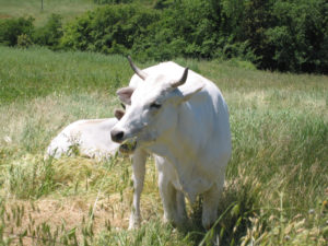
Once we master the decline, the rest of the walk goes quickly and after passing a field with some of the famous white cows of Chiana, we’re soon at the Abbey, three hours after we started from Montalcino with three or four missteps but few if any breaks. Within a minute, Cujo leaves us for some people picnicking in the shade; where’s the loyalty? Honestly though, at this point, I don’t care so much about the Abbey (or losing Cujo) as it’s water I crave. I did bring along a couple of oranges with me because of my blood sugar issues, and I did eat one on the path, just before we encountered the sheep, which helped but I really want some water.
Several times during the hike, we tried to call Osteria del Bassomondo to make a lunch reservation but never got through. So we wing it, hiking past the tour busses and individual visitors to the abbey and make a final ascent to Castelnuove Del Abate for lunch. There’s a sign for Bassomono as we enter the town, it’s to our left.
We sit outside at a small table at a funny angle, crammed in between picnic tables occupied by workmen and once I completely down the first bottle of water our waitress brings, I feel much better.
For our primi, Chris has the pinci con funghi and I have pinci con ragu both are fine, almost delicious but who knows at this point if it’s the food or the fact that we’re ravenous from the walk. For our secondi, we both order the sausage with what we think will be beans (reminiscent of my sausage from last night at Grappolu). Imagine our surprise when we receive sausage accompanied with something that well, looks, like well, I don’t know what it looks like – a large lump of stuffed derma perhaps. Turns out to be pig’s liver sausage! Hey, what did we know, beans and pigs liver both start with ‘F.’ While we eat, a beautiful Siamese cat with the most incredible blue eyes, prowls the tables; she seems to enjoy it as we discreetly feed her a bit of the liver under the table.
We ask the waitress where we can find the bus stop for the bus to Montalcino, “Dove la fermata per autobus per Montalcino?” Okay, maybe not the best attempt, but it works. She points right to the corner in front of the restaurant, cool.
We ask her where we can buy tickets, “Dove possiamo comprare il billegetti?” She tells us on the bus, cool again.
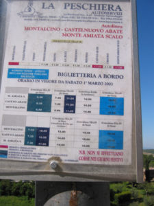 Our female hikers told us the bus stops here at 2:15 and 4:55 (which were the times we saw on a sign on the road across from the gas station in Montalcino) but our waitress tells us 2:30. Later, we realize 2:15 and 4:55 are the time the bus leaves Montalcino to come here. Being the type A personality Chris is, actually I ask him to do it, he runs across the street and checks the sign, which says, 2:25 and 4:55, so who knows. Anyway, we know we need to depart somewhere in that vicinity.
As we’re approaching 2:00, we ask for il conto because we both agree that we’re tired and don’t want to wait until 5:00 to get a bus back; we figure we can always return later with the car and we want to catch the “two-ish” bus. While we’re waiting and waiting, we see a small blue bus go by (maybe 20 seats) but it’s coming from Montalcino. The waitress finally gives us the check, about 2:20 and tells us the bus stops across the street from the sign facing the direction of Montalcino (there’s a blue sign pointing towards Montalcino). By the way, our check for our meal, two bottles of water and two carafes of house red came to about 40€.
We head out to wait for the bus and run into our female hikers who just arrived. Apparently, at the second split, where we followed the wooden arrow pointing left towards Sant’ Antimo, they took the path that went straight toward the Villa Tolli. Our hiking map shows this as an alternate route, maybe to avoid the treacherous route, who knows? Now whether this route was that much longer, explaining the extra two hours it took the female hikers, or that they moved at a slower clip, I cannot say. Nor can I tell you whether that route has trail markings, since we did not take it.
The bus arrives momentarily, and it costs us 1.10€ per person; knocking parking in Bari out of the running as best money spent on this trip. We have the driver drop us near the gas station rather than at Piazza Cavour because Chris wants to stop at Why Not for gelato. We say goodbye to our female hikers who are returning to their B&B, and we head to Why Not. Oh no! They seem to be closed. Chris asks a man sitting out one of their outdoor tables if they’re open and he says, “No.” To which, Chris smiles and exclaims, “Perche No?” It’s a second before the man gets it and smiles. He tells us they’re having trouble with their freezers.
We head towards the next gelato store, on Via Mazzini, but on the way we stop at the olive wood store to make some purchases. Chris holds up a long slim board with a curved bottom and asks what is used for. The owner replies, “Slicing salami.” Chris pretends to saw salami with it, smiles and says, “I don’t think it’s sharp enough.” She laughs. He’s on a tear today. We buy that and a large cutting board then head for gelato. As they’re out of coconut, Chris opts for lemon while I get strawberry and lemon, yum, very refreshing. While in the area, we stop into Les Barriques (enotecca/restaurant) and make a reservation for dinner that night.
We head back to the apartment where we grab a bottle of white wine, our books, my IHT and head to the benches near the Madonna to relax and sip wine for a couple of hours overlooking one of the best views imaginable.
Afterwards, we shower, and head to dinner. We’re not sure about this place; the primi prices seem in line with other establishments but the secondi prices seem high rivaling Boccon Del Vino (about 15€ a plate). Yet we’ve walked buy it every day for five days now and they always have the most delicious looking fresh pasta in the window, so we were tempted to try.
We start with antipasti of crostini with mixed toppings, mushroom, daino (deer), cinghiale and cheese and truffle. Not bad. I have ribollita, which is delicious and Chris has the fresh parpadelle in an herb sauce. I don’t feel tempted by any of the secondi listed so I enjoy some acighe sotto pesto and a house salad (nice with arugula, pecorino and walnuts) instead. Chris gets cinghiale. With a bottle of rosso and some water I believe the bill comes to 73€, which I believe to be a bit too expensive for the food we ordered but still good tasting and good service. Well not too expensive for the food we ordered, I guess it’s just the quality and ambience does not compare to Boccon Del Vino so I resent paying the same prices for secondi but everything else is good.
After dinner, we head over to Fiascheteria for some sambucca and hot cocoa then it’s off to bed.

